At L.A.S.T: Terrain Analysis Tools to Assist in Victim location
Locate, Access, Stabilize and Transport (LAST) is a phrase and acronym often used to describe what is done in Search and Rescue (SAR).
SAR responders spend a great deal of time discussing and training in rescue techniques, the access component of LAST. But before the rescue can begin, we must locate the subject of our efforts if his or her whereabouts are unknown. This is the locate component of LAST.
In February’s blog, I discussed one important aspect of locating a missing person: statistical zones, an important tool when determining a search area. In this blog, I’ll discuss some of the terrain analysis tools used when determining high probability locations within the search area.
Of course, maps are an essential resource and are particularly useful when planning a trip into varied terrain, including mountains. Ruminating over a good topographic map prior to or during a climb or hike is invaluable. Learning to see a topographic map in 3-D and the ability to orient it to terrain around you are skills necessary to safe travel.
The same holds true when investigating where a missing person may have gone. Based on the map, determining the path of least resistance related to the topography is an analysis tool long used by search planners. If the missing person’s intended route of travel is known, it may or may not defy this rule, but it certainly makes the search easier. The person will be along this intended route or may have gone astray at any number of “decision points,” which caused a diversion from the intended route. The decision points are identified through map analysis, combined with both historical and local knowledge. However, there are also other tools available to analyze terrain.
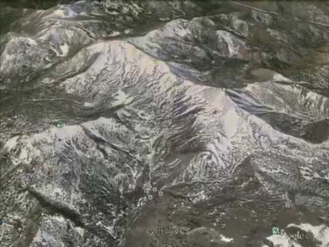
Two very useful ones are Google Earth and its more powerful sibling, Google Earth Pro. Google Earth, which has been used by experienced search managers and planners for a number of years, gives you a bird’s-eye view of terrain based on aerial photography. You can even rotate the view 360 degrees or zoom and look at the terrain from oblique angles. The quality of the view depends on the resolution of the aerial photography, and the imagery is routinely updated. In addition to other enhanced features, Google Earth Pro allows you to “fly” a route, a significant tool when analyzing terrain and identifying potential decision points.
This setting is off the Mt. Rose Highway on the way to Lake Tahoe. The flashing white line is the Nevada-California border. A subscription to Google Earth Pro used to cost several hundred dollars but is now free. Click here for a free subscription.
Terrain analysis and the path of least resistance are tempered by the facts of the case, including the known or presumed intent of the missing person. While there are other tools to accomplish this important component of the investigation, map skills and technological advancements make the job more efficient — and successful.
By Dan Hourihan
Douglas County (NV) Sheriff’s SAR
Past President, MRA